Salher(1567 meters) and its neighboring Salota(1480 meters)
सर्वप्रथम मी वाघाम्बे गाव च्या आश्रमशाळेतल्या शिक्षकांचा आभारी आहे कारण त्यांच्यामुळेच मला हा ट्रेक करता आला इतिहासाचे श्री चौरे सर ,श्री भामरे सर ,श्री जाधव सर ,श्री खैरनार सर आणि श्री मानकर सर या सगळ्यांनी मला वाघाम्बे गावातून एक वाटाड्या उपलब्ध करून दिला
विशेष आभार जाधव सरांना कारण साल्हेर चढायचे म्हणजे त्यांना कधीच कंटाळा येत नाही अगदी कोणत्याही वेळी ते साल्हेर चढायला तयार असतात आणि म्हणूनच त्यांना साल्हेर वरती जायचे असे सांगितल्याबरोबर तयार झाले .साल्हेर माथ्यावरचे परशुराम मंदिराची डागडुजी आणि रंगकाम करायचे होते त्यामुळे जाधव सर यांना त्या संदर्भात माहिती गोळा करायची होती आणि काय काय काम करायचे हे जाणून घेण्यासाठी ते साल्हेर वर येण्यास तयार झाले .वाटाड्या या साठी घेतला कारण जाधव सर गडावर कोणती कामे करायची आहे याची यादी गडाचे निरीक्षण केल्यावर बनवणार होते आणि त्यामुळे थोडा वेळ लागू शकत होता आणि माझी वाघाम्बे हून दुपारची 3:१५ ची सटाणा S T बस चुकली तर जवळ जवळ ८ किलोमीटर ची आलीयाबाद पर्यंत पायपीट होईल .म्हणून जाधव सर यांनी गावातून एक वाटाड्या घेतला म्हणजे तो माझ्याबरोबर पहिले गडावर येईल आणि गडावरची करायची कामे याची यादी करत जाधव सर नंतर मागाहून माथ्यावरच्या परशुराम मंदिरा कडे येतील .Salher is the highest fort in Sahyadris and second highest mountain in Sahyadris and though it is having one base village in Gujrat Dang district but technically,it is located in the Baglan taluka Nasik district(I had one satisfaction that I climbed the maximum of the Maharashtra's highest fort.From Chinchali in Gujrat state,Salher is almost 1200 meters from ground but still 50 meters less climb than the Kulang fort near Igatpuri)
History of Salher
In ancient times, Parshuram the 6th incarnation of Lord Vishnu stayed here at this fort and it is believed that from top of the Salher, Parshuram shot an arrow due to which the ocean receeded behind forming a narrow strip of land called Konkan(ctually Parshuram tried shooting arrow from another mountain near the Warna dam region called Chakdev parvat located near Prachitgad but from Chakdev(Meaning of chakdev is ‘target missed by God’),Parshuram couldn’t aim properly from Chakdev hence he choosed Salher)
From 15th century,Salher was in the mughal rule and was controlled from Surat.Later on during the raid of surat carried out by Shivaji Maharaj in somewhere around year 1670, Chatrapati Shivaji Maharaj handed over a mission to Sardar Moropant Pingale to bring the forts in the Baglan and Nasik region into Swarajya and it started from the raid of Surat.Sardar Moropant Pingale very soon brought the whole Nasik region forts into swarajya which included forts like Salher,Mulher,Chandwad,Ahiwant,Dhodap,Avandh-Patta,Trimbakeshwar,Kavnai,Tringalwadi hence a vast area between the Bhandardara and the Satana region of Nasik was captured till year 1671 and released from the mughal rule.
Due to this,Aurangazeb decided to deploy huge forces to regain Baglan area hence there was a war between Marathas and mughals at Salher.This war was very important because till now,Shivaji Maharaj used guirella tactics against mughals but now,it was a straight challenge on open battle field.Maratha troops fought valiantly and thus the mughal army was defeated at Salher.The defeated mughals ran away from the battlefield and after that, they never thought again of capturing Nasik region.Hence mughals were restricted till Sangamner and aurangabad in the north.But at Salher battle,Shivaji Maharaj’s childhood friend Suryaji Kakade died after fighting valiantly.His Samadhi is located in Salher village.
Later from Marathas,this fort was in control of Peshwas and further,the Peshwas gave this fort to Maharaja Sayajirao Gaikwad of Baroda dynasty .Till 1960,Salher was the part of Baroda and later on after formation of Maharashtra state,this fort is situated in Maharashtra on the Gujrat border
Base villages
Chinchali village Taluka Ahwa dist Dang Gujrat
Manur village , Taluka Baglan Nasik Dist Maharashtra(There are 3 villages named Manur nearby out of which 2 are in Gujrat state and 1 in Maharashtra)
Vaghambe village, Taluka Baglan Nasik Dist Maharashtra (North of Salher fort)
Salher village Taluka Baglan Nasik Dist Maharashtra(Location South of Salher fort.There are regular steps having 6 entrance doors to reach the top)
Manur and Vaghambe are hardly differentiable.From Vaghambe, just after crossing the bridge ahead 200 meters approx, you are into Gujrat state and further descending down approx 300 meters,you are near Chinchali.
How to approach Salher
From Pune/Mumbai reach Satana 70 kms from Nasik(1.5 to 2 hours by bus).From Satana,reach Taharabad which is 22 kms.From Taharabad,there is a 7:30 am bus to Unai(Satana-Unai) bus which reaches Chinchali in 1 hour.Also from Satana,there are buses to Salher.8:00 am bus from Satana to Manur going by Taharabad-Mulher-Aliyabad-Haranbari- Vaghambe reaches the base village in 1 hour.
But I tell you,Satana is the most convinient place for treks in this region
From Satana,there is bus to Unai( સતનાં સે ઉનાઈ ) Maharashtra inter state ST bus around 7:00 am going via Chinchali
From Satana,there is a 7:45 am bus going to Manur via Vaghambe
From Pune,you can reach Satana in following way(Take the 10:30 pm last bus to Trimbakeshwar,you will reach Nasik around 4:00 am.From Nasik,take first bus to Satana around 5;00 am and reach Satana around 6:30 am )
Thus if you reach Satana before 7:00 am from Pune/Mumbai,you can reach Salher in 1 hour by bus(Roads are very good here because after Taharabad-Mulher, maximum part of road is in Gujrat state.and also in Maharashtra state,development of road is going on thus very less problem of bad roads.Roads are bad only near Vaghambe village but this is for only 2 to 3 kms max )
Also there are buses to Salher village from Kalwan around morning.From Salher village,there is a regularroute by steps from the village and also a ashram of Shri Uddhav Maharaj which can be used for a overnight stay
In Vaghambe village,you can make a overnight stay in the school.
In Vaghambe village,you can make a overnight stay in the school.
My trek
I started by the Friday night Shivajinagar to Nawapur St bus around 8:00 pm and reached Taharabad around 4:30 am.It was a lonely deserted ST bus stand and I waited there till 7:15 am when the Satana to Unai bus came there and further,I got down at Chinchali in Dang district of Gujrat around 7:45 to 8:00 am and walked 7 kms via the Telya ghat,climbed approx 300 meters and reached Vaghambe village in Nasik district of Maharashtra around 9:30 am.Thus it was a walk of around 1 hour on the Maharashtra Gujrat border
From Vaghambe,Salher is elevated at 850 meters from ground.
Further I met the teachers in the secondary school of Vaghambe Mr Chaure,Mr Mankar,Mr Khairnar,Mr Bhamare and Mr Jadhav.They wanted to start the painting of the Parshuram temple on the top hence before that,they wanted to do a survey of Salher top hence Mr Jadhav and one student from the school and myself we three headed to Salher around 10:00 am from Vaghambe
Mr Jadhav is also planning to plant around 500 to 1000 nilgiri trees in this rainy season because the top of fort is literally barren. Many times, trees were planted on salher before but almost all trees dried up.We started walking and in 1 hour, we were below the Salota fort at the col between Salher and Salota. Jadhav sir insisted that since I have come from very far, hence we will atleast reach the door of Salota which was near and then descend down to salher.The route to Salota was tough one with narrow route, blown up steps and in few time,we reached the first entrance door of Salota.From here,you can view a pyramid like shape of Salher .Further from Salota door,the route traverses through more difficult path till the top.Now it was around 11:30 am hence we decided to descend down Salota and proceed towards Salher.Again,we came down to the col between Salher and Salota.From here,there are regular steps and 4 entrance doors .The steps are very very steep.They offer you almost a rock climbing of 80 degrees.If you are off balanced, there is no excuse and within a flash,you will reach Chinchali and further…..
After the 4th entrance door, there is a small lake called Gangasagar lake and further,there are many caves to stay.But beware of flies and honeybees. They are plenty here in the caves.
Further from the Gangasagar Talav,there is a small temple of Shri Renukamata .From this temple,the route climbs up till the top which has a temple of Parshuram.There is always a powerful and cold breeze on the top because this point is 1567 meters high above the sea level hence in the temple, you can rest for a while.Jadhav sir was instructing Chotu guide regarding which part of temple to paint and what all things are necessary to do.The language here is completely different.It seems to be Marathi but having Gujrati ascent and a mixture of Marathi and Gujrati.
From top of Salher,the view is finest .You can see the whole Gujrat region till Ahwa-Saputara-Vaghai and the Saptashringi region towards west, Chandwad region towards south and Mangi Tungi Mulher to your east. Salher is the region from where the Sahyadris start.The region between Mangi-Tungi and Salher is the origin point of Sahyadris
After that,we started to descend down and near the caves at Gangasagar,we had our lunch.It was around 1:30 pm hence we started to descend down .At the col between Salota and Salher,we saw 3 peacocks on one tree but immediately after seeing us,they flew away to Salota(while flying,these peacocks were resembling like eagles)
वन्य जीवन :
या भागात महाराष्ट्र राज्यात येणाऱ्या विभागात कोणताही प्राणी शिल्लक नाही आणि पलीकडच्या गुजरात राज्यात आहवा आणि वनसाडा हे दोन अभयारण्य आहेत आणि आता सह्याद्रीत कधी वाघ आढळत नाही पण चिंचली गावाच्या पुढे आहवा आणि वनसाडा च्या जंगलात वाघ सुद्धा आहेत , कधी ते वाघ महाराष्ट्रात हरणबारी च्या धारणापर्यंत येतात आणि आपल्या महाराष्ट्रात तर वन्य जीवात सर्वात समृद्ध समजल्या जाणार्या भीमाशंकर च्या जंगलात सुद्धा बिबटे नाहीसे झालेत(होय हि एक वस्तुस्थिती आहे कि आजच्या घडीला भीमाशंकर अभयारण्यात एक सुद्धा बिबट्या शिल्लक नाही तिथे वाघ कोठून येणार ) .साल्हेर च्या भागात तुम्हाला मोर मात्र बर्याच वेळा बघायला मिळतील आणि बिबटे आणि वाघ तुम्हाला फक्त पावसाळ्यात हरणबारी धरणाच्या जवळ दिसतील
We were back till 3:00 pm at Vaghambe and the 3:15 pm bus to Satana was waiting for me.Jadhav sir was telling me to go to Mangi-Tungi but it was not possible for me to climb the 3000 steps barefooted and that too around 4:00 pm time hence I thought of coming to Mangi-Tungi somewhere in rainy season(Mangi-Tungi is the place which is believed that after Mahabharat, Lord Krishna decided to end up his avatar,he came to the jungles in this region and sat below a tree. The color of Lord krishna’s skin was resembling like a deer skin hence by mistake, one hunter due to this mirage could not understand it and shot a arrow from his bow which hit Lord Krishna and thus ended his avatar here. Further his elder brother Balram did the final rites on the Mangi-Tungi mountain )
The bus to Satana left around 3:15 pm from Vaghambe and reached Satana around 4:45 pm.There was a 5:00 pm Satana-Pune bus waiting on the St stand and thus by getting this bus,I reached Pune around 2:30 am and further around 4:30 am to reach home.
Thus after this trek, I have trekked the first 7 highest mountains in Sahyadris according to their rankings(Kalsubai 1648m-Salher 1567m-Ghanchakkar-1532m-Muda 1520m-Kirda 1516m-Salota 1480m-Kulang 1471m)
Here are the photos
Salher while climbing from Manur-Chinchali after climbing up Telya ghat.(जमिनीपासून ते वरच्या टोका पर्यंत साल्हेर कॅमेर्या च्या फ्रेम मध्ये कसाबसा बसवला .चिन्चली वरून तर तो इतका मोठा आहे कि एका फ्रेम मध्ये फक्त अर्धा साल्हेर बसतो )
Near Vaghambe, after crossing Gujrat border,Salher is now visible.(The topmost point of salher from the Telyachi bari or Telya ghat).The photo shown earlier is the photo after climbing Telyachi Baari
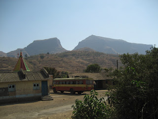
Reached the school in Vaghambe village
From Vaghambe Salher(Right) and Salota(Left)
Close view of Salher and Salota
Our chotu guide at the col between Salota and Salher
The col between Salher and Salota
Vaghambe village left far behind.almost 50% salher done here.Can you notice a white building to the right.There is Vaghambe.
For your information,this much height from ground is Rajgad fort near Pune and this is not even half Salher climbed hence you can imagine how much huge climb is Salher the highest fort of Maharashtra
For your information,this much height from ground is Rajgad fort near Pune and this is not even half Salher climbed hence you can imagine how much huge climb is Salher the highest fort of Maharashtra
After descending Salota.I cant believe that I was able to climb here.Just notice the small streak in the rock.Those are the steps to reach the door of salota
Steps to Salher.These are carved in the rocks.(A peculiar 'S' shape route in the steps.These steps are almost 80 degrees inclined)

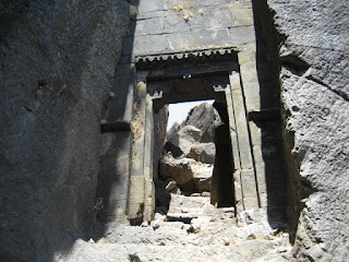
Entrance door to Salher
From the entrance door no 2. Be careful at this point.Offbalancing has no excuse at this point
Chotu guide at a cave near Salher
Myself at one cave at Salher.(Jadhav sir was far behind and was busy in making a more detailed survey hence he told chotu guide to quickly reach the Salher top and he will come after doing some survey)
Entrance door to Salher.By Vaghambe route,Salher has got 4 entrance doors and from Salher village to the south,it has got 6 entrance doors.The speciality of these entrance doors is that,each door is unique in design.No two doors look the same
Gangasagar Talav on Salher top
Shri Renukamata temple near Gangasagar Talav
Caves on Salher.One can stay here but beware of flies and honeybees.They are plenty here.
A view of Gujrat-Maharashtra border from Salher.To the right,on the high Plateau is Maharashtra and to the left side,down after descending the Plateau is Gujrat.This point is the starting point of Sahyadris
Top of Salher.The temple of Parshuram.Padukas of Bhagwan Parshuram are kept here at this temple
Breathtaking view of Salota fort from Salher top.Also far away Mulher and Mangi Tungi are seen
Gujrat-Maharashtra Border
Parshuran temple on the top.I have delibrately not taken photos inside the temple since it is a sacred place.Those who want to see Padukas of Bhagwan Parshuram ,he has only one option "Climb salher and see it"
To the west and south.Below is the Salher village where the famous battle of Salher was fought in 1671.Far west,is Vaghai-Saputara and Saptashringi mountains
Salota
Back to Vaghambe village.The 3:15 pm St bus to Satana was waiting for me??(Till Haranbaari and Aaliyabad,I was the only passenger in this bus )


