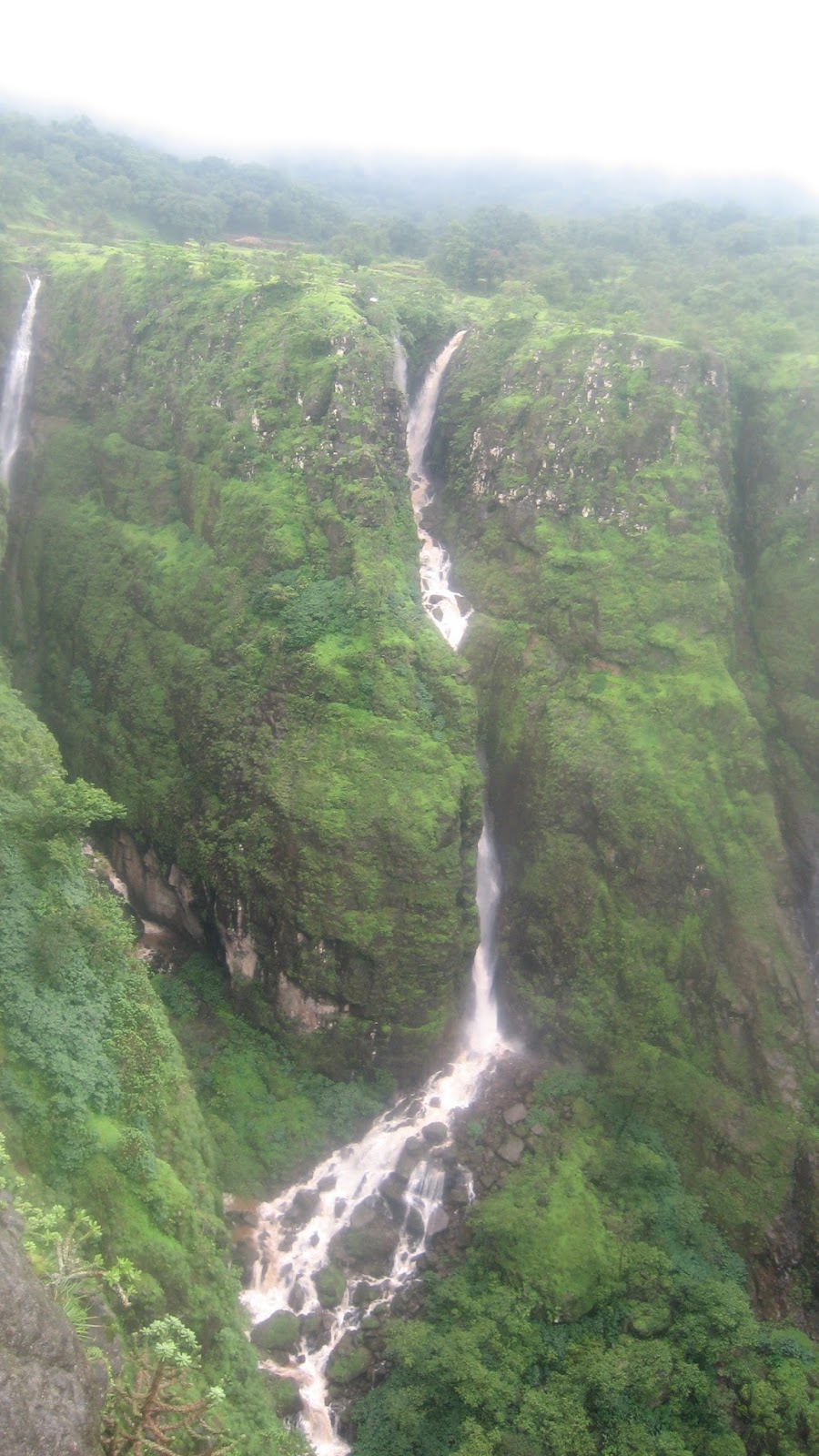
The area from Ahupe to Kondhwal is an area which comes under core area of Bhimashankar wild life sanctuary and mountains like Ahupe,Damdamia,Ghonemal are located in this area and are not much accessible.Dense forests and no human settlements for miles makes this trek a very challenging
Ahupe to Kondhwal is a 9 kms walk and further 4 kms is Bhimashankar whereas Bhorgiri is a 7 kms walk further from Bhimashankar so this total area of forest is more than 200 sq kms
We planned a trek from Ahupe to Damdamia and further to Ghonemal and hence from Pune, We started around 6:30 am and reached Ahupe till 12:30 pm.It was a journey beyond Dimbhe dam backwaters.Ahupe is 48 kms from Dimbhe dam but takes too much time
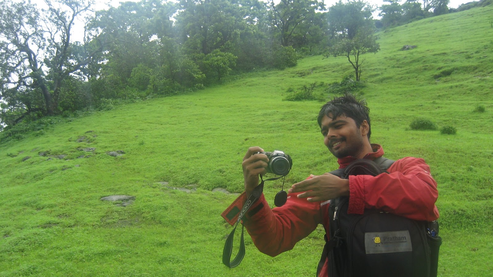
We were 4 people I with Anirban,Kiran and Sudarshan.
How to reach Ahupe
From Pune
From Manchar, take the road towards Bhimashankar, you will reach Ghodegaon(12 kms) further 10 kms is Dimbhe colony.From here you will see wall of Dimbhe dam to your right.From here you will see a small road going towards right and left towards Bhimashankar.From here, leave the Bhimashankar road and turn right towards Dimbhe dam wall. From here,Ahupe is 48 kms
From Konkan(You have to climb 600 meters trek )
Reach Dehri/Khopivali(Base villages of Gorakhgad).From here climb the plateau between Gorakhgad and Ahupe ghat. You will reach Der Maata temple just below pinnacle of Gorakhgad.From here , climb down into the valley and a steep route in dense forests and through the waterfall will lead you to Devrai of Ahupe after 2.5 hours climb approx
From Bhimashankar
Take a bus from Manchar towards Bhimashankar and just 5 kms before Bhimashankar, get down at Kondhwal Fata.You will see a Tar road going towards your right and a board written Ahupe 15 kms.
Follow this Tar road (After 2 kms, this is not a Tar road and this is a normal bullock cart road in the forests)
6 kms after walking, you will reach Kondhwal village.Further walking on this road, you will reach Ahupe which is 9 kms .Our Trek route was exactly reverse of this.From Ahupe, we were following the route towards Bhimashankar and reach Damdamia
आहुपे कडून दमदम्या /भीमाशंकर कडे कसे जायचे ?
आहुपे गावात आल्यावर आपल्याला डावीकडे एक आश्रमशाळा दिसेल , त्या शाळे पासून डावीकडे एक बैल गाडी ची वाट तुम्हाला जंगलात गेलेली दिसेल . हीच वाट आहुपे -> कोंढवळ -> भीमाशंकर पर्यंत जाते (१५ कि मी ). या वाटेने जंगलातून कधी उतार तर कधी चढ करत तुम्हाला खाली साधारण ३०० फुट खोल दरी दिसेल आणि दाट आणि भले मोठे पठार त्या दरीत दिसेल . या पठाराला साखर माची म्हणतात
हे पठार ओलांडून पुन्हा कोंढवळ कडे निघाल्यास पुढे "भट्टीचे रान " हे ठिकाण दिसेल . या ठिकाणी Forest check post आहे आणि सुदैवाने कोणी माणूस येथे असला तर तुम्ही दमदम्या ला जाणारी वाट विचारू शकतात . या check post पासून उजवीकडे जंगलात गेलात कि दमदम्या आणि खाली कोकणात सिद्धगड कडे उतरणारी वाट ज्याला बैल घाट म्हणतात त्या वाटेने जावे लागते आणि सरळ गेलात कि कोंढवळ-घोनेमाळ -भीमाशंकर पर्यंत पोहोचता येते
But instead of Damdamia, we reached a different mountain
How???
It is a total different story
"चालती का नाम गाडी " या चित्रपटात एक किशोर कुमार ने गाणे गायलेले आठवते का ज्याच्यात शब्द असे पण आहेत " हम थे वो थे और समा रंगीन समझ गये ना , जाते थे जापान पोहोच गये चिन समझ गये ना "
या जंगलांनी , तिथल्या वातावरणाने इतकी भुरळ पडली कि आम्हाला जायचे होते दमदम्या ला पण पोहोचलो खेतोबा ला
पण जे होते ते चांगल्या साठीच होते
साखर माची पर्यंत पोहोचल्यावर जंगलात खूप आत आलो होतो आणि तीन डोंगर एकदम एक सारखे दिसत होते ,आणि सगळे आमच्या उजवीकडे होते जिथे आम्हाला जायचे होते आणि या मध्ये दमदम्या नक्की कोणता हे ओळखता येत नव्हते कारण विचारायला कोणाच नव्हते , भट्टीचे रान दिसत नव्हते तसेच सिद्धगड पण दिसत नव्हता ज़र सिद्धगड दिसला असता तर दमदम्या ओळखता आला असता कारण सिद्धगड आणि दमदम्या हे एकमेकांच्या शेजारी आहेत त्यामुळे आम्ही असे ठिकाण शोधत होतो कि जिथून सिद्धगड पण दिसू शकतो
त्यामुळे आमच्या उजवीकडे असलेल्या पहिल्या डोंगर कडे निघालो . अर्धा तास झाल्यावर आम्हाला खाली दरीत साखर माची आणि लांब सिद्धगड दिसला आणि तेव्हा कळले कि त्या तीन एक सारख्या दिसणाऱ्या डोंगरांमध्ये सर्वात शेवटी व लांब असलेले डोंगर म्हणजे दमदम्या पण तिथे जायचे म्हणजे ती दरी उतरून साखर माची च्या पलीकडे जायचे आणि त्या जंगलात कुठे तरी उजवीकडे वळणारी वाट धरायची पण विचारण्या साठी कोणी माणूस दिसत नव्हता. आम्ही पुन्हा साखर माची कडे निघालो
दूर लांब वर त्या जंगलात आम्हाला एक मावशी येताना दिसल्या .आम्ही लगेच धावत तिकडे पोहोचलो . त्या मावशी कोंढवळ येथून आहुपे कडे चालल्या होत्या त्यांना आम्ही दमदम्या बद्दल विचारले पण दमदम्या खूप लांब होता कारण आता दुपारचे तीन वाजले आणि मग परत यायला रात्र होईल असे त्या मावशींचे म्हणणे होते
त्यामुळे आम्ही ठरवले कि पुढच्या वेळेला रात्री एस टी ने आहुपे ला यायचे आणि मुक्काम करायचा आणि पहाटे भीमाशंकर कडे याच वाटेने निघून दमदम्या-घोनेमाळ चा ट्रेक करत भीमाशंकर कडे यायचे
आता आमच्या कडे ३ तास शिल्लक होते त्यामुळे दुसरे काही ठिकाण पण आम्ही बघत होतो कारण आम्हाला आहुपे गावात संध्याकाळी ५:३० पर्यंत पोहोचायचे होते
त्या मावशींकडून आम्ही दुसऱ्या वाटेची माहिती करून घेतली जी आहुपे च्या सर्वात उंच ठिकाणी(११५० मीटर ) जाते ज्याला स्थानिक लोक खेतोबा म्हणतात . त्या वाटेने आम्ही निघालो
We walked almost 6 kms in forests from Ahupe and there were 3 mountains which were looking same and all were on our right side it was not possible for us to identify which is Damdamia.There was nobody in this forest to tell us hence we decided to search from all possible directions.We explored first mountain towards right and after climbing it,we realized that we were very far away from Damdamia.After climbing this mountain, we were able to see Siddhagad far away and since Siddhagad and Damdamia is close, we realized that we were diverted to a different direction.In the meantime, very far away,we saw one lady in forest whom we asked and confirmed about Damdamia.But now it was very late because it was almost 3:00 pm we had to descend down towards a plateau and then climb Damdamia thus it will be almost night time to reach Ahupe so we decided to do it next time by coming early in morning to Ahupe
Now we started our journey back and then we saw a small route going towards left in the dense forests.We asked the lady once again.She told that this route is towards Khetoba temple and it is used by people to descend into Konkan via Sakhar Maachi Plateau and since it can be reached in around 1 hour hence we decided to go here and then come back to Ahupe.So the lady going to Ahupe went ahead and we took left into the dense forests and after climbing and walking through the huge plateau filled with igneous volcanic rocks , we reached the Khetoba temple in around 45 minutes and that to without panicking on a huge plateau with many confusing routes in dense forests and nobody to guide us.
We reached this place which is the topmost point(1150 meters) in Ahupe-Bhimashankar region
So after this, we reached the topmost point of Ahupe in next 10 minutes and further around 4:30 pm , we again started our journey back to Ahupe , we reached back to village around 6:00 pm and started back to Pune around 6:30 pm


Ahupe to Kondhwal is a 9 kms walk and further 4 kms is Bhimashankar whereas Bhorgiri is a 7 kms walk further from Bhimashankar so this total area of forest is more than 200 sq kms
We planned a trek from Ahupe to Damdamia and further to Ghonemal and hence from Pune, We started around 6:30 am and reached Ahupe till 12:30 pm.It was a journey beyond Dimbhe dam backwaters.Ahupe is 48 kms from Dimbhe dam but takes too much time
We were 4 people I with Anirban,Kiran and Sudarshan.
How to reach Ahupe
From Pune
From Manchar, take the road towards Bhimashankar, you will reach Ghodegaon(12 kms) further 10 kms is Dimbhe colony.From here you will see wall of Dimbhe dam to your right.From here you will see a small road going towards right and left towards Bhimashankar.From here, leave the Bhimashankar road and turn right towards Dimbhe dam wall. From here,Ahupe is 48 kms
From Konkan(You have to climb 600 meters trek )
Reach Dehri/Khopivali(Base villages of Gorakhgad).From here climb the plateau between Gorakhgad and Ahupe ghat. You will reach Der Maata temple just below pinnacle of Gorakhgad.From here , climb down into the valley and a steep route in dense forests and through the waterfall will lead you to Devrai of Ahupe after 2.5 hours climb approx
From Bhimashankar
Take a bus from Manchar towards Bhimashankar and just 5 kms before Bhimashankar, get down at Kondhwal Fata.You will see a Tar road going towards your right and a board written Ahupe 15 kms.
Follow this Tar road (After 2 kms, this is not a Tar road and this is a normal bullock cart road in the forests)
6 kms after walking, you will reach Kondhwal village.Further walking on this road, you will reach Ahupe which is 9 kms .Our Trek route was exactly reverse of this.From Ahupe, we were following the route towards Bhimashankar and reach Damdamia
आहुपे कडून दमदम्या /भीमाशंकर कडे कसे जायचे ?
आहुपे गावात आल्यावर आपल्याला डावीकडे एक आश्रमशाळा दिसेल , त्या शाळे पासून डावीकडे एक बैल गाडी ची वाट तुम्हाला जंगलात गेलेली दिसेल . हीच वाट आहुपे -> कोंढवळ -> भीमाशंकर पर्यंत जाते (१५ कि मी ). या वाटेने जंगलातून कधी उतार तर कधी चढ करत तुम्हाला खाली साधारण ३०० फुट खोल दरी दिसेल आणि दाट आणि भले मोठे पठार त्या दरीत दिसेल . या पठाराला साखर माची म्हणतात
हे पठार ओलांडून पुन्हा कोंढवळ कडे निघाल्यास पुढे "भट्टीचे रान " हे ठिकाण दिसेल . या ठिकाणी Forest check post आहे आणि सुदैवाने कोणी माणूस येथे असला तर तुम्ही दमदम्या ला जाणारी वाट विचारू शकतात . या check post पासून उजवीकडे जंगलात गेलात कि दमदम्या आणि खाली कोकणात सिद्धगड कडे उतरणारी वाट ज्याला बैल घाट म्हणतात त्या वाटेने जावे लागते आणि सरळ गेलात कि कोंढवळ-घोनेमाळ -भीमाशंकर पर्यंत पोहोचता येते
But instead of Damdamia, we reached a different mountain
How???
It is a total different story
"चालती का नाम गाडी " या चित्रपटात एक किशोर कुमार ने गाणे गायलेले आठवते का ज्याच्यात शब्द असे पण आहेत " हम थे वो थे और समा रंगीन समझ गये ना , जाते थे जापान पोहोच गये चिन समझ गये ना "
या जंगलांनी , तिथल्या वातावरणाने इतकी भुरळ पडली कि आम्हाला जायचे होते दमदम्या ला पण पोहोचलो खेतोबा ला
पण जे होते ते चांगल्या साठीच होते
साखर माची पर्यंत पोहोचल्यावर जंगलात खूप आत आलो होतो आणि तीन डोंगर एकदम एक सारखे दिसत होते ,आणि सगळे आमच्या उजवीकडे होते जिथे आम्हाला जायचे होते आणि या मध्ये दमदम्या नक्की कोणता हे ओळखता येत नव्हते कारण विचारायला कोणाच नव्हते , भट्टीचे रान दिसत नव्हते तसेच सिद्धगड पण दिसत नव्हता ज़र सिद्धगड दिसला असता तर दमदम्या ओळखता आला असता कारण सिद्धगड आणि दमदम्या हे एकमेकांच्या शेजारी आहेत त्यामुळे आम्ही असे ठिकाण शोधत होतो कि जिथून सिद्धगड पण दिसू शकतो
त्यामुळे आमच्या उजवीकडे असलेल्या पहिल्या डोंगर कडे निघालो . अर्धा तास झाल्यावर आम्हाला खाली दरीत साखर माची आणि लांब सिद्धगड दिसला आणि तेव्हा कळले कि त्या तीन एक सारख्या दिसणाऱ्या डोंगरांमध्ये सर्वात शेवटी व लांब असलेले डोंगर म्हणजे दमदम्या पण तिथे जायचे म्हणजे ती दरी उतरून साखर माची च्या पलीकडे जायचे आणि त्या जंगलात कुठे तरी उजवीकडे वळणारी वाट धरायची पण विचारण्या साठी कोणी माणूस दिसत नव्हता. आम्ही पुन्हा साखर माची कडे निघालो
दूर लांब वर त्या जंगलात आम्हाला एक मावशी येताना दिसल्या .आम्ही लगेच धावत तिकडे पोहोचलो . त्या मावशी कोंढवळ येथून आहुपे कडे चालल्या होत्या त्यांना आम्ही दमदम्या बद्दल विचारले पण दमदम्या खूप लांब होता कारण आता दुपारचे तीन वाजले आणि मग परत यायला रात्र होईल असे त्या मावशींचे म्हणणे होते
त्यामुळे आम्ही ठरवले कि पुढच्या वेळेला रात्री एस टी ने आहुपे ला यायचे आणि मुक्काम करायचा आणि पहाटे भीमाशंकर कडे याच वाटेने निघून दमदम्या-घोनेमाळ चा ट्रेक करत भीमाशंकर कडे यायचे
आता आमच्या कडे ३ तास शिल्लक होते त्यामुळे दुसरे काही ठिकाण पण आम्ही बघत होतो कारण आम्हाला आहुपे गावात संध्याकाळी ५:३० पर्यंत पोहोचायचे होते
त्या मावशींकडून आम्ही दुसऱ्या वाटेची माहिती करून घेतली जी आहुपे च्या सर्वात उंच ठिकाणी(११५० मीटर ) जाते ज्याला स्थानिक लोक खेतोबा म्हणतात . त्या वाटेने आम्ही निघालो
We walked almost 6 kms in forests from Ahupe and there were 3 mountains which were looking same and all were on our right side it was not possible for us to identify which is Damdamia.There was nobody in this forest to tell us hence we decided to search from all possible directions.We explored first mountain towards right and after climbing it,we realized that we were very far away from Damdamia.After climbing this mountain, we were able to see Siddhagad far away and since Siddhagad and Damdamia is close, we realized that we were diverted to a different direction.In the meantime, very far away,we saw one lady in forest whom we asked and confirmed about Damdamia.But now it was very late because it was almost 3:00 pm we had to descend down towards a plateau and then climb Damdamia thus it will be almost night time to reach Ahupe so we decided to do it next time by coming early in morning to Ahupe
Now we started our journey back and then we saw a small route going towards left in the dense forests.We asked the lady once again.She told that this route is towards Khetoba temple and it is used by people to descend into Konkan via Sakhar Maachi Plateau and since it can be reached in around 1 hour hence we decided to go here and then come back to Ahupe.So the lady going to Ahupe went ahead and we took left into the dense forests and after climbing and walking through the huge plateau filled with igneous volcanic rocks , we reached the Khetoba temple in around 45 minutes and that to without panicking on a huge plateau with many confusing routes in dense forests and nobody to guide us.
We reached this place which is the topmost point(1150 meters) in Ahupe-Bhimashankar region
So after this, we reached the topmost point of Ahupe in next 10 minutes and further around 4:30 pm , we again started our journey back to Ahupe , we reached back to village around 6:00 pm and started back to Pune around 6:30 pm
 |
| Trek Map of Ahupe Region |
 |
| Just Before reaching Ahupe.Flowers like Kass Pathar on our way |
 |
| Trek Route to Bhimashankar from Ahupe village |
 |
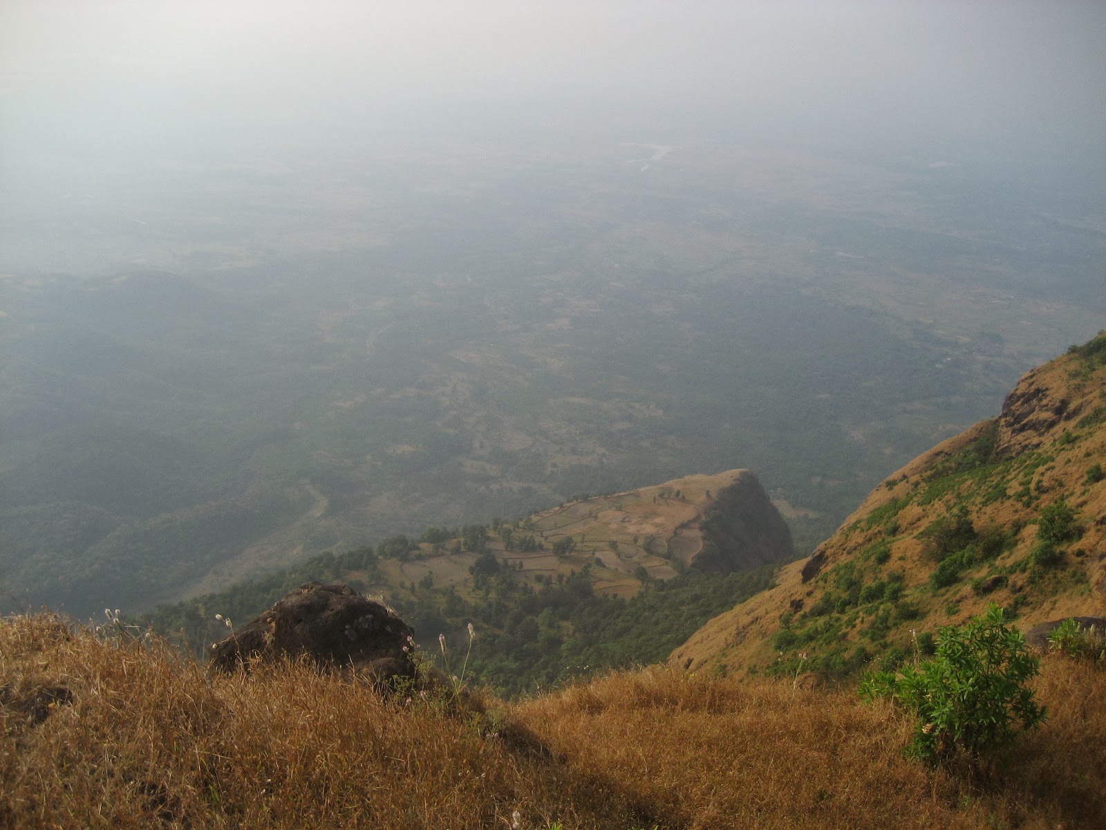
| Plateau of Ahupe and the village seen below |
 |
| This was the topmost point where we reached instead of Damdamia |
 |
| Inside the Bhimashankar Wildlife Sanctuary.We spotted a Giant Indian Squirrel here |
 |
| Far to our front the Damdamia mountain.This Place is towards Sakhar Maachi siddhagad having a huge plateau and very rarely with any human settlements for miles.This is the core area of Bhimashankar Wildlife Sanctuary |
 |
| Towards Sakhar Maachi into the core area of Bhimashankar |
 |
| Our route to the Ahupe topmost point after dropping idea of Damdamia |


 |
| Ahupe topmost point |
 |
| A view of Siddhagad to front |
 |
| Siddhagad (Front) and Damdamia(Left) where we intended to go initially |
 |
| Khetoba temple on top of Ahupe |
 |
| A view of Sakhar Machi village below Ahupe |


 |
| View of Ahupe Plateau till Dhakoba-Nane Ghat area |
 |
| The small hill to front from where, we left the Bhimashankar route and entered the forests to come at this place |
 |
| View of Konkan from Ahupe. This is one route to descend down in Konkan |
 |
| Damdamia(Left 1003 m) the mountain from where britishers fired cannons on Siddhagad(982 m) in 1821 because from Konkan, britishers were not able to capture sidhagad hence they brought cannons on top of Damdamia |
 |
| Gorakhgad and Siddhagad from Ahupe.We reached here till 6:00 pm evening |